Features
- Mapping program indicates relative position of vessels reporting in a DSC transmission
- Mapping screen can be centered on distress or at operator’s discretion
- Mapping screen can display chart or map available to operator in a .jpg format
- One click access to map from regular console display or can be displayed on split screen if operating system allows
- If there is a distress call, the position of the vessel in distress flashes to alert operator to vessels in the area that could respond
- Mapping is integrated into the operator console and is an option available with purchase of console
- No separate interface needed to install mapping
About
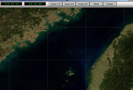
The TransOceana map function option runs on the TransOceana Operator Console application. The map function provides an easy to use method for displaying ship locations on a regional map without having to purchase or interface to 3rd party map applications.
If a DSC message is received with a position, then the map is automatically updated with the location and MMSI of the vessel. This feature is integrated with the virtual receivers within the operator console to selectively filter what is added to the map. The map display always centers on the last position added making it easy to locate the vessel.
Landmarks and positions of other special interest can be added to the map and saved in a database. Layers can be defined by the operator to add or remove location types. By integrating the map function with a virtual receiver, an alert can be sounded when the map is updated. For example, if a distress call within a geographic area is received, the map will be updated and an alert sounded.